First S-100 test products ready for piloting
S-100 products provide the maritime sector with more accurate, up-to-date, and interoperable data, improving both safety and efficiency in navigation. In Finland, development has progressed to the piloting phase as part of the international collaboration under the Baltic Sea e-Nav project.
Development of Finnish S-100 products has reached a significant milestone with the creation of the first test products compliant with the new product specifications. As part of this work, Traficom produced the initial versions of the Electronic Navigational Chart (S-101 ENC) and the Bathymetric Surface (S-102). At the same time, the Finnish Meteorological Institute introduced test versions of the Water Level Information (S-104) and Surface Currents (S-111) products. While the test products meet the required technical standards, the data content is not yet suitable for operational use.
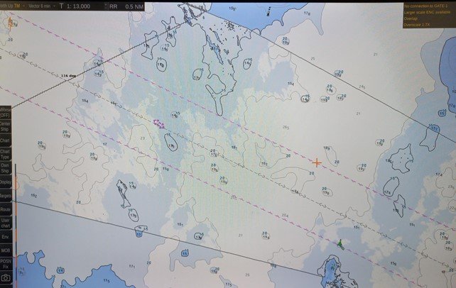
S-101 and S-102 testa data displayed in an ECDIS simulator
With the completion of the test products, the Baltic Sea e-Nav project has entered the piloting phase. Piloting provides insights into product performance and helps identify areas for further development. A key aspect of the piloting is displaying these products on S-100-compatible ECDIS devices: often, seeing the data visualized on a chart reveals both its practical utility and any potential usability challenges.
Another central aim of the piloting is to ensure interoperability between different product types. The results achieved can also feed into the ongoing development of international interoperability standards (S-98). While the product specifications define the technical requirements of S-100 products, data providers have some flexibility regarding content. Testing the products through broad Baltic Sea collaboration supports the formation of a common implementation approach, aiming for a harmonized and user-friendly end product for mariners.
The piloting work in the Baltic Sea e-Nav project is led by Satakunta University of Applied Sciences (SAMK), RISE Research Institutes of Sweden, and e-navigation software developer Furuno Finland Ltd. Activities began in spring 2025 in SAMK's navigation simulators and will later move to real-world piloting on the bridge of a test vessel.
As part of piloting the S-100 production and distribution chain, the test products have been published in the test environment of the centralized distribution service PRIMAR (a RENC). The process meets the requirements of operational distribution, enabling testing of the data delivery channel and associated quality control. In Finland, distribution of ENCs compliant with the current S-57 standard is also handled via the same RENC.
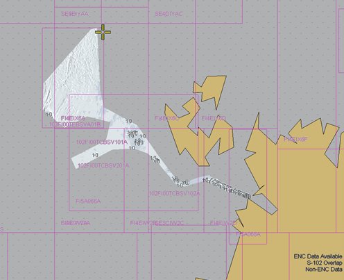
Finnish S-102 test products (white area) for the Vaasa-Umeå test area
The test products have attracted broad interest, and the possibility of extending them to wider testing is being explored. Several technical questions have also arisen related to the digital distribution model. While this model often remains invisible to the end user, resolving related issues is essential for both data providers and distributors to ensure a smooth user experience.
Further information
Read more about the first phases of piloting in the Baltic Sea e-Nav project and progress in Baltic-wide collaboration on the project’s website.